

3 Minute Read
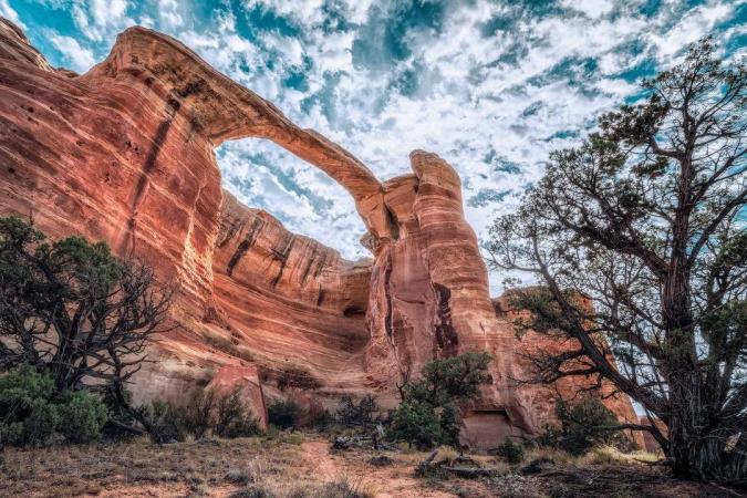
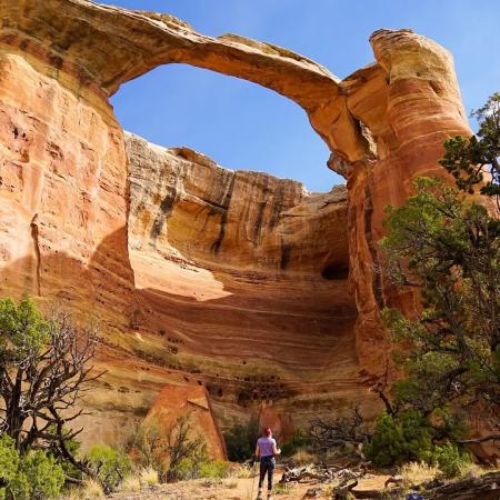
The northern end of Western Colorado’s Uncompahgre Plateau is defined by remote canyons that slice through colorful sandstone layers to form cliffs, pinnacles, alcoves, and - most impressively - arches. In fact, you can find a collection of 35 natural arches, including eight major arches, tucked away in Rattlesnake Canyon. These soaring spans, protected in the 123,400-acre McInnis Canyons National Conservation Area, form the world’s second-largest concentration of arches outside of Utah’s Arches National Park.
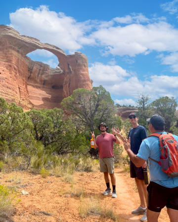
The Rattlesnake Canyon Arches are one of Colorado’s most spectacular wonders, but also one of its best-kept secrets. The Rattlesnake Arches are off the beaten path, but those willing to make the journey will be rewarded with one of Colorado’s most remarkable landscapes. Bonus: they can be hiked without the crowds experienced in Moab, Utah; however, the Arches are accessible with a high-clearance 4x4 vehicle or a 15-mile round-trip trek from a trailhead west of Grand Junction so some planning is involved. A third option, which is most recommended, is hiring a guide. Grand Junction Adventures and Adrenaline Driven Adventures have expert guides that know the area and will teach you a variety of history and interesting information about the Grand Junction area.
There are two routes to consider when getting to Rattlesnake Arches:
1) Pollock Bench Trailhead via Fruita
15-mile strenuous roundtrip hike
If you’re up for the ultimate challenge, start at the Pollock Bench trailhead. This 15-mile round-trip hike is considered strenuous and requires some technical scrambling, so starting this trek in the morning and packing plenty of water is highly recommended. You shouldn’t take your dog on this route, as there is little shade and no water. Wear protective clothing, hats and sunscreen.
To get to the trailhead, drive west on Horsethief Canyon Road (aka Kingsview Rd.). At the Pollock Bench Trailhead, there is a large parking lot with vault toilets.
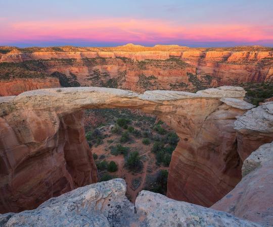
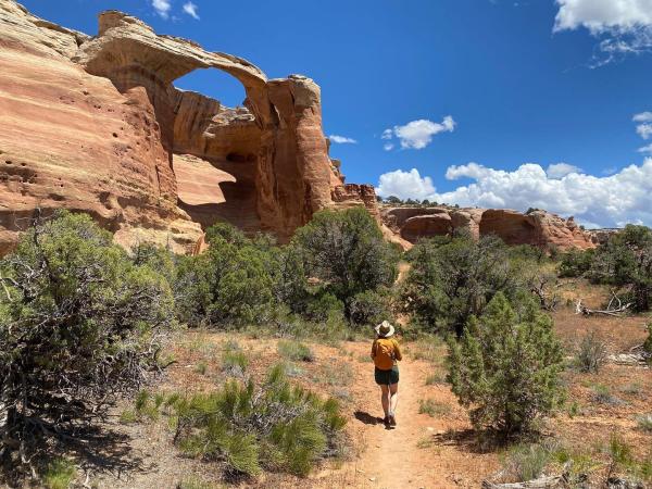
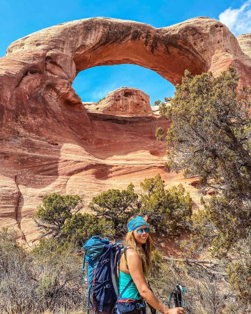
As you hike from the trailhead, follow the Pollock Bench trail which is designated by a P1 marker. You will come to forks on the trail at 1.6 miles, 1.8 miles and 2 miles (from the trailhead) – take a right each time. From here to the arches, you will arrive at sections that require minor scrambling, sliding down on your bum, technical hiking skills and some 4 - 5-foot cliff sections that need to be carefully scaled. At 3 miles, you will see a fork where Rattlesnake Arches trail meets the Pollock Canyon trail – veer right (west) again. After carefully maneuvering your way through, you will be rewarded with the sight of a unique rock formation, called Window Rock Tower. At 6 miles, the upper trailhead meets the lower trailhead route, stay right. At 6.7 miles, you will see the Hole in the Bridge arch sitting between two other arches. At about 7 miles, you will see the famous Rattlesnake Arch which spans 120 feet high and 40 feet wide. Hike another .75 miles to arrive at Cedar Tree Arch, the final arch from this route. At this point, retrace your steps back to the trailhead.
2) Upper Trailhead via Glade Park
Less hiking; however, requires high-clearance 4-wheel drive vehicle
There are two access roads to get to the Upper Trailhead depending on the time of the year you plan to visit. For either access road, enter the east entrance to Colorado National Monument. Take Rim Rock Drive to 16 ½ Road. About 1,000 feet after turning left onto 16 ½ Road, turn right on Black Ridge Road. Follow Black Ridge Road until you come to a fork in the road.
- Upper Black Ridge Road (Upper Access Road): Open 4/15 - 8/14
- Lower Black Ridge Road (Lower Access Road): Open 8/15 - 2/14
- Both closed: 2/15 - 4/14 (due to wet conditions/snow melt)
The route on the right is the Lower Access Road and is open from August 15 to February 14. The Upper Access Road is on the left and is open from April 15 to August 14. After the two routes converge, the last two miles to the trailhead is considered the roughest section of the drive, so many people hike or bike the remaining distance. From Rim Rock Drive to Rattlesnake Arches trailhead, it takes about 75 minutes regardless of which access road you are on.
After reaching the trailhead, begin hiking and you will come to a fork marked by a signpost with the words "Upper Trail", "Lower Trail", and "Trailhead". At this point, follow the Upper Trail for 1/2 mile to view an overlook of Cedar Tree Arch as well as some of the other arches. To descend into Rattlesnake Canyon, backtrack to the previously mentioned signpost and follow the trail that is marked as "Lower Trail". After turning left onto Rattlesnake Arches Lower Trail, continue until you reach another fork. At this point, stay left. Follow this trail for about 2 miles to see the arches from the bottom. The trail ends at the bottom of Cedar Tree Arch. Retrace your steps to return to the previous fork.
No matter which trail you choose, you will be rewarded with stunning, natural landscapes surrounded by red rocks.
Rattlesnake Canyon Visitor FAQ: Wildlife, Camping, and Tours
-
What wildlife do you see on the hike?
-
You’ll most likely encounter lizard species scurrying along the trail or the surrounding areas. Given the area's desert environment, it's reasonable to anticipate sightings of reptiles, birds, and small mammals. Always exercise caution and respect local wildlife by observing from a distance and adhering to Leave No Trace principles.
-
-
Where to camp near Rattlesnake Canyon?
-
Camping directly within Rattlesnake Canyon is restricted. Specifically, camping is prohibited within 1/4 mile of the Rattlesnake Arches Loop and along the access road to the trailhead. However, there are several nearby camping options:
-
Saddlehorn Campground: Located within Colorado National Monument, this campground offers established sites and is accessible via Rim Rock Drive.
-
Dispersed Camping Near Mee Canyon Trailhead: Some visitors have found suitable dispersed camping spots along the Upper Road, approximately a 15-minute drive from the Rattlesnake Canyon Trailhead. Please note that camping at the Mee Canyon Alcove is prohibited.
-
-
-
When is the best time to visit Rattlesnake Canyon?
-
The optimal times to hike Rattlesnake Canyon are during the spring (March–May) and fall (September–November). During these periods, temperatures are milder, making for a more comfortable hiking experience. Summer months can be hot with minimal shade, so if you choose to hike then, it's advisable to start early in the morning or later in the evening to avoid peak heat.
-
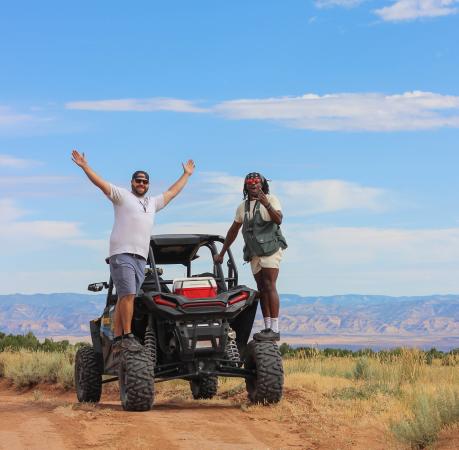
Photo by: Karrin Melton
-
Are there guided tours at Rattlesnake Canyon?
-
Yes, guided tours to Rattlesnake Canyon are available:
-
Adrenaline Driven Adventures: This company offers a combined RZR and hiking tour to Rattlesnake Arches. The adventure includes off-road travel through rugged terrain, culminating in a hike to the arches. It's designed for those seeking both an OHV thrill and natural beauty.
-
Grand Junction Adventures: They offer guided hiking tours tailored to various skill levels. Their Rattlesnake Arches tour includes a scenic drive through Colorado National Monument, a 13-mile 4WD journey on Black Ridge access road, and a 3.2-mile hiking loop showcasing several arches. The tour provides knowledgeable guides who share insights about the area's history, flora, and geology.
-
Both tours provide transportation and expert guidance, enhancing the overall experience of exploring Rattlesnake Canyon.
-
For more information on public land in the Grand Junction area, check out pages 19-21 of the Grand Junction Adventure Guide!