

6 Minute Read
Grand Junction offers some of the most diverse and striking landscapes in the country. Mountain peaks tower above at 11,330 feet in contrast to nearby lowlands that wind through the valley floor as low as 4,700 feet. The juxtaposition of rugged mountain summits and canyons against the serene terrain of valleys and orchards provides a breathtaking, picturesque view. Now is the perfect time to set off and explore the breathtaking panoramic highs and inspiring lowlands that frame Grand Junction.
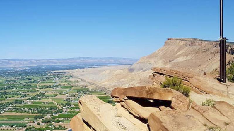
Mt. Garfield
Open: year-round
Peak elevation: 6,765 ft
Mt. Garfield is one of the most well-known Grand Junction mountains and a favorite for locals to hike. Located only 20 minutes east of town, its steep sandstone facades and broad flat top make it a great spot for hiking. Mount Garfield, which is part of the Book Cliffs, features two hiking trails, both of which depart from the Mt. Garfield trailhead off I-70 near Palisade. The shorter but more challenging trail is the Mt. Garfield Trail, which is a steep 3.4-mile roundtrip hike that ascends 2,000 feet. Climb up the steep trail and meander next to a mountain wall, stop at the top for a quick picnic, and watch as birds and other wildlife dance around to celebrate your journey.
The 5-mile roundtrip Gearhart Mine Trail diverges from the main trail and takes hikers to the historic Gearhart coal mine. Both trails are very steep, so plan for several hours to complete the journey, and be sure to pack plenty of water and snacks. The climb may be strenuous, but the panoramic views of Grand Junction and Palisade from the summit are more than worth the effort—and perfect for a photo op with the American flag which towers over the Grand Junction area from the top!
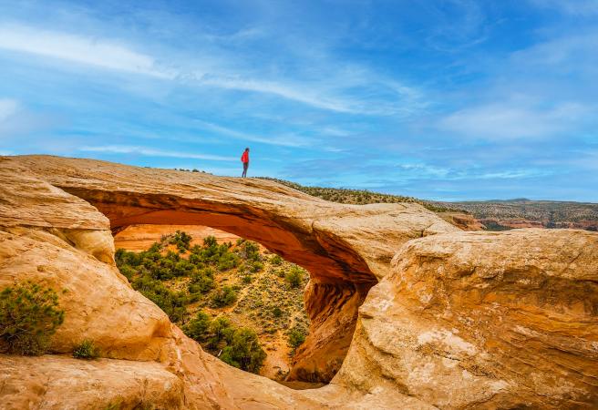
Rattlesnake Arches
Open:
Upper Black Ridge Road (Upper Access Road): Open 4/15 - 8/15
Lower Black Ridge Road (Lower Access Road): Open 8/15 - 2/15
Both closed: 2/15 - 4/15 (due to wet conditions/snow melt)
Peak elevation: 5,856 ft
Rattlesnake Canyon, nestled in the Black Ridge Canyons Wilderness, is renowned for having the second largest concentration of natural arches in the world. Arches National Park is first, but you need a reservation for timed entry and it’s often quite crowded. The famous Cedar Tree arch has a massive span of 76 feet. You can hike the rusty red landscape of Rattlesnake Arches and try to spot as many of the 35 natural arches as you can. There are two ways to enter the Arches.
The most popular hiking trail in the canyon is the Rattlesnake Arches Loop. Pollock Bench Trailhead is a 15-mile roundtrip hike that, while challenging, gives you stunning scenery and a sense of accomplishment. You will be awestruck by the dozens of natural arches while watching wildlife who thrive in the area. During the summer and early fall (June – September), it can be significantly hot and there are very few spots for shady breaks, so bring lots of water and snacks if you hike during this time of year. Although dogs are allowed, we don’t recommend you bring your furry companion during this time of year. Late fall and winter (October – February), as well as spring (March – May) is the perfect time to hike this trail since the temperate weather is much more comfortable.
The other option to enter the arches is through the Upper Trailhead entrance. This requires a high-clearance vehicle to get you to the trailhead and from there it is only 3.2 miles round trip to see the arches.
This helpful map and article explain both options in detail. If you would like to learn more about the Arches, here is a list of articles that share a wide array of information.
Ute Canyon
Open: year-round
Peak elevation: 6,440 ft
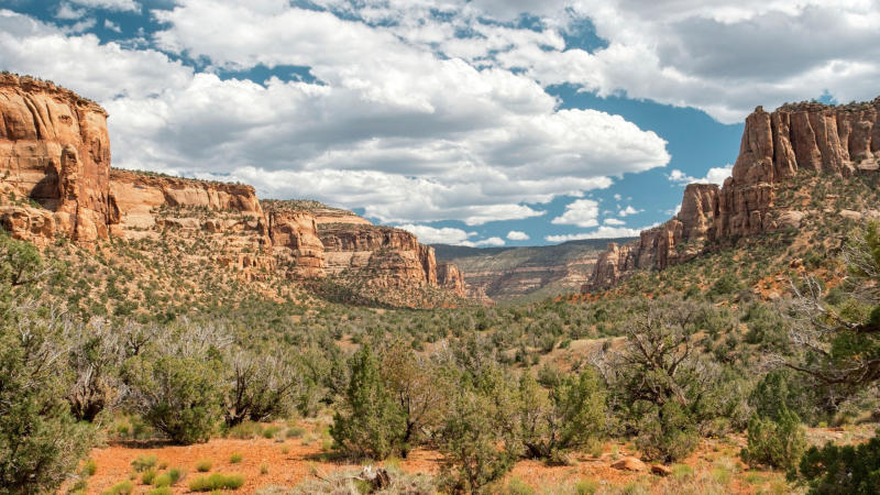
Colorado National Monument, which guests affectionately call the “mini-Grand Canyon,” is only six miles from Downtown Grand Junction. A popular Monument trail is Ute Canyon which is surrounded by red sandstone canyons and descends over 500 feet, with a winding path coupled with a few stair steps. Unlike other trails in Colorado National Monument, you become immersed in lush vegetation while the red rock canyons peek through sagebrush, shrubs and indigenous grasses like pinyon pine and Utah juniper. At the base of the canyon, the trail continues through verdant landscapes with incredible views of the canyon walls surrounding it. The Ute Canyon Trail is 11 miles out and back. The trail can be accessed by Rim Rock Drive, which will showcase the striking vistas from your car.
Devil’s Canyon
Open: year-round
Peak elevation: 5,245 ft
Despite the intimidating name, Devil’s Canyon is a one-of-a-kind (and not at all scary) spot for hiking and horseback riding. Located in the McInnis Canyons, a National Conservation Area, it is known for its stunning sandstone canyons and unusual and large-scale rock formations. Devil’s Canyon has numerous trails, including a 7-mile loop that tracks through a diverse environment of naturally sculpted cliffs and dramatic canyons. Saunter along red dirt and feel the warm sun as it follows you through the canyon. Dogs on leashes are welcome as well! Devil’s Canyon is particularly breathtaking at sunrise, when the sun bathes the rocky landscape in warm, rich hues.
Big Dominguez Canyon
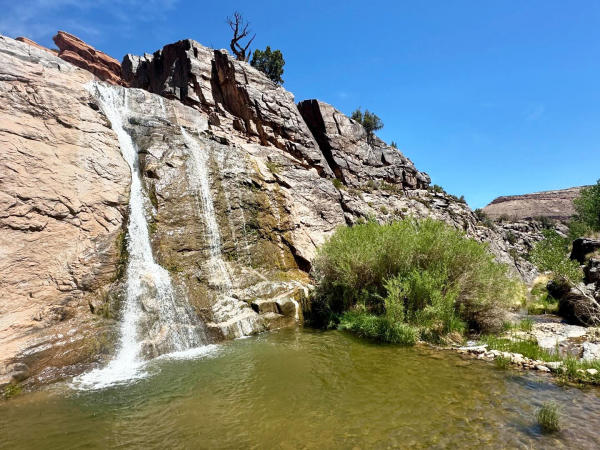
Open: year-round
Peak elevation: 5,523 ft
With a trailhead located just a half-hour drive from Grand Junction, Big Dominguez Canyon is the perfect day trip for hikers to experience a combination of flora, fauna and history. The canyon is in the Dominguez-Escalante National Conservation Area and is best known for its many natural waterfalls and a series of protohistoric and historic petroglyphs carved into red sandstone. You may also spot bighorn sheep climbing up stone cliffs in the canyon and in warmer months you can cool off in one of the area’s peaceful swimming holes. Big Dominguez Canyon Trail is a 12.5 mile out-and-back trail with 1,076 feet in elevation gain. The petroglyphs, rock shelters and enchanting waterfalls make this an entertaining hike. Keep an eye out for bighorn sheep too! This trail offers rewarding views at every turn, making it a must-explore for outdoor enthusiasts and historians.
Leon Peak
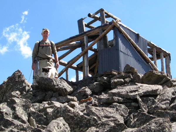
Opens: late May to early June
Peak elevation: 11,236 ft
At just over 11,000 feet, Leon Peak holds the title of the highest point in Mesa County, and the second highest point on the Grand Mesa. Leon Peak offers a great vantage point for taking in the expansive landscape of the broad Grand Mesa, the world’s largest flat-top mountain. The pristine landscape is the perfect background for a stellar photo. The Leon Peak Trail is an out-and-back route that spans just over 3 miles, takes hikers through serene forests and over rocky ridges and boulders. The shady trail provides a nice retreat from warmer weather thanks to the scenic tree canopies. Wildlife is abundant in this area – from easily spotted chipmunks and deer to the less conspicuous moose who roam the Grand Mesa. There are currently over 400 moose who roam this lush area. When you reach the top of Leon Peak, you’ll find the remains of a log structure, which was built over a century ago and functioned as a fire lookout, though only for a short period due to recurring lightning strikes. You can access Leon Peak Trail from the Leon Lake trail 717, which can be found at the Weir and Johnson Campground on FR126.
Crater Peak
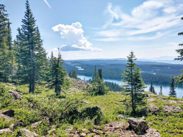
Opens: late May to early June
Peak elevation: 11,333 ft
While Leon Peak offers breathtaking terrain, Crater Peak is about 100 feet taller, making it the highest point of the entire Grand Mesa. Crater Peak is stunning throughout the spring, summer and fall and is best known for its hiking trails and backcountry camping. The Crater Peak trail can be accessed from near the Goodenough Reservoir, which does pass through some marshy areas, so good mosquito repellent or cover is recommended in the early summer. Pass by vibrant spring wildflowers in bloom and deer as they graze through the open areas around the trail. Once you’ve reached the rocky top of the highest Grand Mesa peak, enjoy the amazing panorama in front of you, with landmarks like Mt. Hatten, Chalk Mountain and the Goodenough reservoir on the horizon.
Fuel to Hike

Before you hit the trail for your next big adventure, make sure you fuel up and stock up on snacks for your trek. Stop in at Betty’s Gourmet Coffee in Hotel Maverick and try their bagel sandwiches, breakfast burritos, or pastries. Be Sweet Café & Bakeshop has an extensive breakfast from biscuits & gravy to Belgian waffles and many to-go options. Main Street Bagel’s has an assortment of baked goods, ranging from homemade bagels to muffins and cinnamon rolls. Café Sol on Main Street opens at 8 am and offers breakfast salads, pancakes and smoothies. At some point during your visit to Grand Junction, Copeka Coffee is a must stop – it’s retro chic aesthetic has a cool vibe, friendly staff, and also sells beer, wine, and mocktails – open daily until 8 pm!
For more ways to explore Grand Junction, check out the Official Grand Junction Visitor Guide.